Straight-line wind vs tornado damage: reading the pattern from the air
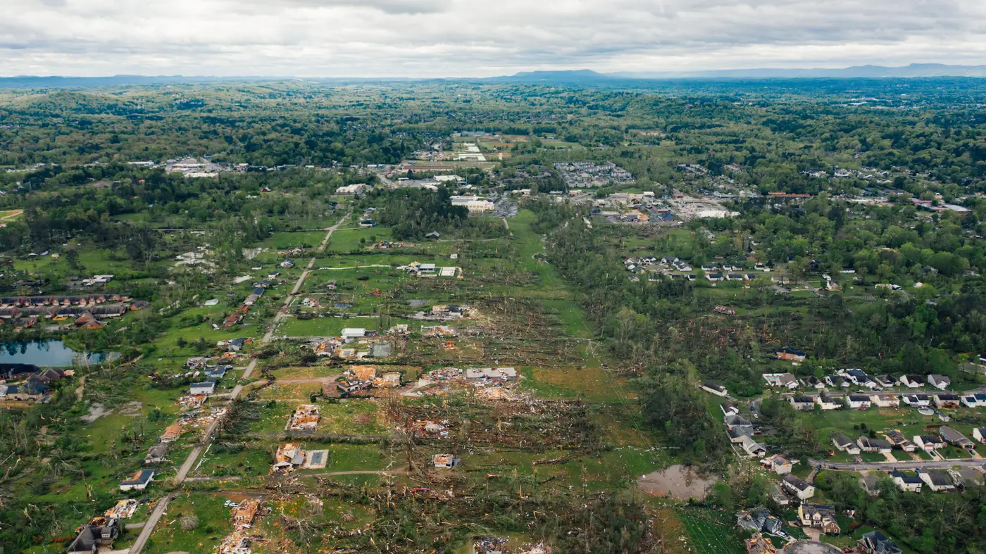
The storm's through, the first imagery is landing on your desk, and you need to know one thing fast: are you looking at a tornado track or a straight-line wind event. It's not an academic question. It decides whether you deploy a tight team to a narrow corridor or spread adjusters across a county-wide footprint at lower intensity per roof.
What a tornado swath looks like from above
A tornado damage swath reads as a path, not a zone. From the air it's narrow, usually a few hundred feet to maybe a mile wide, and it rarely holds a straight line. Look for a track that curves, jogs, or loops slightly as it crosses the ground. Inside that path, damage is severe and concentrated: roofs stripped to the deck, framing exposed, debris scattered in a pattern that looks pulled toward a center rather than pushed in one direction. Trees inside the track often fall toward each other or in conflicting directions on either side of the centerline, a signature of rotation rather than a steady push.
The boundary matters too. Tornado damage tends to start and stop abruptly. A home with a missing roof can sit fifty feet from a home with barely a shingle disturbed. That sharp edge is one of the clearest tells you'll see in high-resolution imagery, and it's the detail that separates a tornado claim from a straight-line wind claim when the narrative from the ground is thin or contradictory.
Straight-line wind and the derecho damage pattern
Straight-line wind, including the broad derecho damage pattern that shows up after a fast-moving line of severe thunderstorms, behaves differently. Instead of a narrow track, you're looking at a wide corridor, sometimes tens of miles across, where the damage spreads evenly across the footprint and tends to be less severe per structure. Debris falls in a consistent direction across the whole area. Downed trees point the same way, fences lean the same way, and loose roofing material scatters downwind rather than toward a center point.
There's no sharp edge the way there is with a tornado. Damage fades gradually as you move away from the core of the wind event, which makes a derecho damage pattern harder to bound on a map but easier to confirm once you've got two or three data points showing the same fall direction over a wide area. If you're staring at imagery and every downed tree in a ten-mile stretch points the same way, you're looking at straight-line wind, not a tornado swath.
Why the distinction changes your deployment call
The distinction decides how you move people on day one. A confirmed tornado track means you can draw a tight polygon, know the worst damage sits inside it, and send your most experienced adjusters straight there while the rest of your footprint gets a lighter pass. A derecho or straight-line wind event means the opposite problem: damage spread thin across a huge area, with no single corridor to prioritize, so you need per-building grading to find which roofs took the worst of it before you start routing trucks.
That's the gap a per-building damage grade closes. Instead of waiting for drive-by surveys to tell you where the hail-dented siding ends and the stripped roofs begin, a grade assigned to every structure in the storm footprint from very-high-resolution satellite or aerial imagery lets you set reserves and prioritize adjusters to the worst-hit buildings before a single truck leaves the lot. For a tornado track, that means confirming the severity gradient inside the swath. For a derecho, it means finding the pockets of real damage buried inside a wide, shallow footprint where most of the damage is cosmetic.
Either way, the imagery itself usually tells you which event you're dealing with before the first adjuster report comes in. Fall direction, swath width, and boundary sharpness are the three things to check first, and none of them require a meteorologist on the call to read.
If your team needs that per-building read as soon as the imagery comes in, that's the whole reason Windstorm Damage exists.